The topics of this blog are Armand-Jean du Plessis, Cardinal Duke of Richelieu, and the IDEAL CITY built on his command next to his magnificent CHÂTEAU on the borders of Touraine, Anjou and Poitou, in France.

Wednesday, 29 June 2011

Abbé Henri Proust's garden inspiration

...click on the picture to see the details within...
"What do you think of my new raised beds, Beatrice?" by Pieter Van Avont (1600-1652)


***

Wednesday, 22 June 2011

The 'Carte de Cassini' - around Richelieu

The entire area of the Carte de Cassini
Following the full cartological triangulation of France, the King's administration created the Carte de Cassini, a standardised map version of every part of France.
the cité idéale - click on the maps to enlarge

Started on the order of Louis XIV, the 'Carte de Cassini' or the 'Carte de l'Académie' is the oldest of the maps of France in its entirety, created at a consistent topographical scale.  It is also the first map in the world to be created on the basis of geodesic triangulation. It was measured by Jacques Cassini de Thury (1677-1756) of the Académie Royale des Sciences from 1683 to 1744, based on the preliminary work of his own father and grandfather.

After the publication of the 'Carte Générale' on 18 sheets at a scale of 1:870,000 in 1746/47, and now on the request of Louis XV, César-Francois Cassini (1714-1784) conceived a much more detailed map at a scale of 1:86,400 (1 line for 100 toises (194.9 m) = 2.256mm. The field work and engraving of the maps onto copper undertaken starting in 1750 were not completed until 1815. Many additions or corrections, mainly focusing on the lines of communication, were made to the engraving plates between 1798 and 1812.

During the summer of 1756, Cassini presents the sheet Beauvais 2 to Louis XV. The king admires the precision, but the announces to the cartographer that the Royal Treasury can not help the company any further. 

Financial support, essential to the continuation of the work of the Cassini, is provided by a new Association of fifty members, which include the King, Queen and the Cassini family. This Association covers 20% of expenditures. Sales of sheets, subscriptions, and participation of the Généralités and contracts with the Pays d'États allow Cassini to keep the balance of accounts. Along with the publication of the map sheets of the Carte Générale, contributions from provincial expenditures (38%) lead to the publication of special maps of the Languedoc, Burgundy, Bresse and Provence.

In 1793, the revolutionary Convention nationale vote the transfer of the 165 sheets completed to the Depôt de la Guerre. They become an important mechanism for the cutting of France into the new system of départéments

The map making company of Jaques' son, César-François Cassini de Thury, was continued in 1815 by his son Jean-Dominique, Comte de Cassini (1748-1845). 

The Cassini map consists of a collection of 180 sheets, 154 in the format 104 cm x 73 cm and 26 sheets of various other sizes. The copper plates are kept by the National Geographic Institute (IGN) that administrate and publish the print-outs in black and white. 

The four corners of each sheet mark the distances in toises to the Meridian of Paris and its Perpendicular. 
At a scale of 1:86,400 and toise worth 1.949 metres, the size of the field of each map is 77,961 x 48,726 metres (in Cassini projection) for a full sheet.

round and about Richelieu

the Chinonnais, the Indre and the Loire
***

A Richelieu movie

Tuesday, 21 June 2011

Sarko drops the proposed new property tax on secondary homes

The old town of Richelieu attracts many purchasers of houses from abroad, as the pretty cité idéale does not offer many possibilities of comfortable employment to local sons and daughters, far as it is from the cities of Tours or Châtellerault with their job opportunities.  Houses are quite cheap as a result.

Without these foreign buyers, who spend restoration money on the classic properties from wealth earned elsewhere, many of the houses located within the city's walls would be left to rot, as locals do not have either the funds or the inclination to take them on.

The new tax was to have been 20% of the valeur locative cadastral - notional rental value - of the houses per annum.  As many of these properties are large, and the new property tax was to be based on these large areas, while little houses would only have attracted a smallish sum in addition to the impôts habitation et foncière already paid by second home owners, the large houses would have attracted new tax requests in the order of 2,000€ per annum.  As existing local taxes are already quite steep on these large houses, it would have discouraged buyers and caused a reduction of prices and values.

So many second home owners can relax (for a while!)....

for details of the policy change
and HERE
and Here

Also the Sarko administration has improved the position of property owners when the

Grim Reaper
 comes to call
in the land of
Napoléon Bonaparte

CLICK HERE

***

Wednesday, 15 June 2011

The Cartes de Trudaine of 1745 - 1780

The so-called 'Cartes de Trudaine' are a collection of three thousand maps of the various regions of France assembled by the metropolitan Ponts et Chausées in the years 1745 -1770.

The Atlas of Highways in France, called the  'Atlas Trudaine', constitute a unique and consistent sixty-two volume collection of Atlases of maps, in all totalling over 3000 carefully hand drawn sheets, each tinted in watercolor. They are held in the French National Archives (formerly the Centre Historique des Archives Nationales (CHAN)) in Paris. Made between 1745 and 1780 on the orders of Charles Daniel Trudaine, the Director of Ponts et Chausées, they show all bridges and roads, existing and proposed, with their immediate surroundings that were within the twenty-two Généralités des Pays d'Élections governed by royal Intendants.  The Pays d'États (Burgundy, Provence, Languedoc and Brittany) and the Pays d'Imposition (border regions conquered by Louis XIV) are excluded from coverage of the maps, but the Généralité of Metz has three atlases and Haut-Cambrésis three atlases as well.

These atlases are a valuable and highly useful documentation of the eighteenth-century French landscape. They include representations of populated places, woods, streams and roads, isolated buildings (crosses, shrines, castles, mills, factories, quarries ...), and the the sites of all works of art close to roads or actually built upon them.

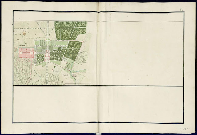
Below, we show three of these maps of the region around Richelieu, it being located in the Généralité of Tours.
  • The Cité Idéale and château de Richelieu
  • The road from Richelieu to Champigny-sur-Veude
  • The town plan of Champigny-sur-Veude 
The maps show the state of the locality in the lifetime  of the third duc de Richelieu, Maréchal Armand de Vignerot du Plessis

As these maps are a record of roads and bridges between various locations, they cannot sustain the etiquette of 'North upwards'; In the Richelieu map East is upwards; in the road to Champigny the East remains upwards; in the Champigny map South is upwards.

The town and castle of Richelieu

the five kilometre road between Richelieu and Champigny-sur-Veude
The town of Champigny-sur-Veude
the Généralités of 18th century France


***
this post dedicated to Liezel, a researcher for criticalproductive at Cornell University, with many thanks for the inspiration...
***

Tuesday, 14 June 2011

The 5th Festival de Musique de Richelieu, 27 July - 7 August 2011

click on the image to enlarge it


***

the cardinal duc on the dike at La Rochelle

Henri-Paul Motte painted this well-known history picture in 1881 showing the cardinal duc on the dike that he ordered to be constructed across the mouth of the bay at La Rochelle.  By screening the fortified town from support from the sea - and the dastardly rosbifs led by the Duke of Buckingham - he ensured the siege of the town in 1627-28 was successful.  The calvinist Hugenot Hanseatic town, a 'state within a state', was brought to its knees and finally capitulated to the King's forces.

one of the battle pictures at the town museum
portrays the siege of La Rochelle

look at the map opposite for the location...

***

Thursday, 9 June 2011

The 'Puits Doré' starts to expand

The town's hotel , the Puits Doré - 'The Golden Well' - is expanding its premises.  The building works have started on the rear wing of their hôtel particulier on the south-western flank of the main town square, the place du marché.  The expansion will provide the hotel with more bedrooms, which in turn will ensure the continued viability of the business.  We have been told that the Puits Doré has been an operating hotel almost from the founding of the Ideal Town in the 1640s.  

Meanwhile the hotel continues to receive visitors and set  a jolly tone on the south side of the square.

It must be important for this little town that tourism can support and sustain such a hotel, as tourism and its grandiose history, cultural and architectural, are the aspects of the town that differentiate it from its myriad neighbours, each struggling to find a purpose in a dispersed agricultural world where the farms are de-populated by modern mechanisation.  Richelieu remains a centre for quite a large farming area as the good Cardinal had the farsightedness and ruthlesness to ensure that his new town did not have urban competitors closer than about 20km - Loudun, Chinon, L'Isle Bouchard, St Maure de Touraine, each at arm's length.  This 'isolation zone' maintains the serenity and tranqillity of the place, but sets it a bit aside from the mainstream.

The main front of the hotel on the place du Marché

The façade onto the Grande Rue, showing the part under renovation.

The hotel finally occupies the entire hôtel particulier, 2 Grande Rue.

the new rear façade to rue du Chantier, next to the Porte de Châtellerault.

the mason's sign.
It will be interesting to see to what extent the Bâtiments de France will require the renovated premises to be 'restored' to a more authentic state, and whether the strict line they have taken recently will be continued.  We will follow the works over the next few months and find out.
***

Wednesday, 8 June 2011

Richelieu - 'Ville fleurie'

This year the town council of Richelieu has taken upon itself to smarten the town up a bit by planting trees and shrubs in the straight and rather minérale streets of the 17th century 'grid' town.

Firstly, and most formally, they have installed caisses de Versailles on the boundary line of each successive hôtel particilier - mansion - on the Grande Rue.  In each caisse is planted a tapered hornbeam (carpinus betulus fastigiata), about three meters high.  Over successive seasons these will be pleached to be trim tall pyramids.  Such planting is contentious with Bâtiments de France as some think that such 'softenings' are inappropriate and out of style for the 17th century period.  This seems (to H. Proust) to be a bit strict as a point of view, as the little town has of course lived through subsequent centuries and amassed all sorts of later influences (cars, or neon pharmacy signs for example!) that change the perceived character and 'authenticity' of the town.

The Grande Rue with its new caisses de Versailles
Despite these stylistic worries, the 24 planters have now been installed, and the effect is quite striking in such a dogmatically axial street.

a new hornbeam

...and another...

...floral planting in each tub...
Secondly, smaller matching planters have been installed on the church steps and elsewhere on the place du Marché.  While there were planters in front of the church, the new ones soften the rather naked facade.  The main trees that encircle the new square layout were omitted in front of the church, allegedly to allow large church services and particularly funerals.  A mistake in HP's view.  So these new church planters improve matters, and could be moved if circumstances require.

the church steps with new planters
Thirdly, property owners not located on the Grand Rue were asked if they would like to have a plant installed in the concrete pavement, adjacent to their own house's façade.  This offer as been taken up in quite a few locations.  While the caisses will be watered by the municipal bowser, individuals will have to water their own new plantings.

new pavement plantings


A older planting installed in the same way but now fully grown up, looks like this.

on rue Traversière

Tuesday, 7 June 2011

Another blog, this time from Braye-sous-Faye, just outside the Parc walls

'Colin and Elisabeth' covered the Ascension day brocante on Thursday 2nd of June 2011 rather well on their own blog.  

The large market of interesting second-hand objects and antiques filled the place du marché and les halles. Abbé Henri Proust was sorely tempted, and finally purchased three things; a pewter plate, an old shotgun, a 'Lefaucheux', marked St. Etienne 16.8mm side-by-side pin-fire hunting piece - un fusil à broche - from about 1880 - HP's era - (but can this really be a man of the cloth, one asks?), and a small sea scene in oils in a gilt frame.

originally from Chatillion-sur-Indre in Berry to the East

All the town's other shops closed for the afternoon.

***